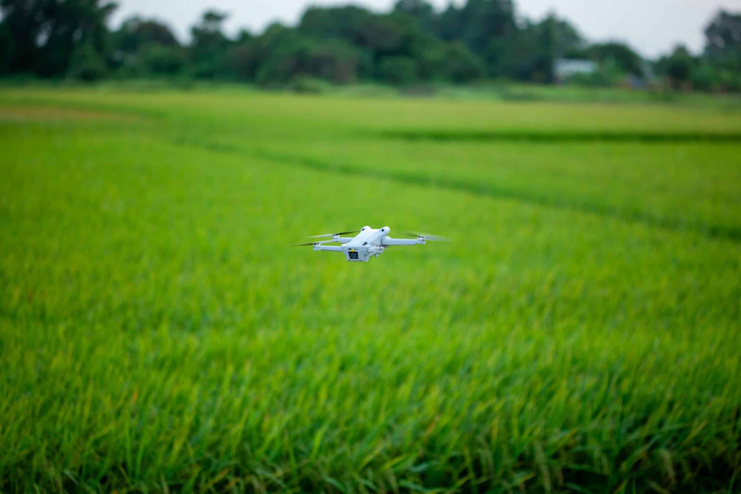
Drones are transforming modern agriculture by enabling precise, real-time crop monitoring that saves time, reduces costs, and maximizes yields like never before.
🚁 The Agricultural Revolution Taking Flight
Agriculture has always been at the mercy of human observation, manual labor, and educated guesswork. Farmers traditionally walked their fields, visually inspecting crops for signs of disease, pest infestation, or water stress. This method, while tried and tested over centuries, is time-consuming, labor-intensive, and often catches problems too late to prevent significant damage.
Enter drone technology—a game-changing innovation that’s rapidly redefining how we approach crop monitoring and farm management. These unmanned aerial vehicles, equipped with sophisticated sensors and cameras, are giving farmers unprecedented access to detailed, actionable data about their fields. What once took days or weeks to assess can now be accomplished in hours, with far greater accuracy and insight.
The integration of drones into agricultural practices represents more than just technological advancement; it’s a fundamental shift toward precision agriculture. This approach leverages data-driven insights to make smarter decisions about resource allocation, pest management, irrigation, and harvesting schedules. The result? Healthier crops, reduced environmental impact, and significantly improved profitability.
Understanding Drone Technology in Agricultural Context
Agricultural drones come in various configurations, each designed to meet specific farming needs. Fixed-wing drones offer extended flight times and can cover vast areas quickly, making them ideal for large-scale operations. Multi-rotor drones, particularly quadcopters and hexacopters, provide superior maneuverability and hovering capabilities, perfect for detailed inspections of smaller or irregularly shaped fields.
The real power of agricultural drones lies not in the aircraft themselves, but in the sensors and cameras they carry. Multispectral cameras capture light beyond the visible spectrum, revealing plant health indicators invisible to the human eye. Thermal imaging sensors detect temperature variations that signal irrigation problems or disease. High-resolution RGB cameras provide detailed visual documentation of crop conditions and growth patterns.
Key Technologies Powering Agricultural Drones
GPS and GNSS systems enable precise positioning and autonomous flight paths, ensuring consistent data collection across multiple flights. Advanced flight controllers process real-time data from multiple sensors, maintaining stable flight even in challenging weather conditions. Cloud-based software platforms transform raw drone data into actionable insights through sophisticated algorithms and machine learning.
The batteries and power systems in modern agricultural drones have evolved significantly, with many models now offering 30-45 minutes of continuous flight time. This extended endurance means farmers can cover more ground per flight, reducing the overall time needed for comprehensive field surveys.
📊 The Spectrum of Crop Monitoring Capabilities
Drone-based crop monitoring extends far beyond simple aerial photography. These systems provide multidimensional data that reveals the true state of agricultural operations in ways previously impossible.
Vegetation Health Assessment Through NDVI
The Normalized Difference Vegetation Index (NDVI) is perhaps the most valuable metric drones provide to farmers. By measuring the difference between near-infrared light (which healthy vegetation strongly reflects) and red light (which healthy vegetation absorbs), NDVI creates detailed maps showing exactly which areas of a field are thriving and which are struggling.
These vegetation maps use color gradients—typically from red to green—to instantly communicate plant health status. Dark green areas indicate robust, healthy crops with optimal chlorophyll content. Yellow to red zones signal stress from disease, pests, nutrient deficiency, or water problems. This visual intelligence allows farmers to target interventions precisely where needed, rather than treating entire fields uniformly.
Early Disease and Pest Detection 🔍
One of drone technology’s most valuable contributions to agriculture is early problem detection. Many crop diseases and pest infestations create subtle changes in plant temperature, color, or growth patterns days or even weeks before symptoms become visible to ground-level observation.
Thermal imaging can detect the elevated leaf temperatures that often accompany fungal infections or insect damage. Multispectral analysis identifies the specific light reflection patterns associated with various diseases. By catching these problems in their earliest stages, farmers can implement targeted treatments that prevent widespread crop loss and reduce the need for broad-spectrum pesticide applications.
Water Management and Irrigation Optimization 💧
Water is agriculture’s most precious resource, and drones are revolutionizing how farmers manage it. Thermal sensors identify areas of excessive moisture or drought stress by detecting temperature variations across the field. Wet soils and well-hydrated plants appear cooler in thermal imagery, while dry areas show elevated temperatures.
This information enables variable rate irrigation—applying water only where and when it’s truly needed. For farms using center pivot or drip irrigation systems, drone data can identify malfunctioning sprinklers, clogged emitters, or system leaks that waste water and create uneven crop growth. The water savings can be substantial, often reducing consumption by 20-30% while actually improving crop yields.
Drainage problems that lead to waterlogged soils and root diseases also become immediately apparent in drone surveys. Farmers can then implement targeted drainage improvements or adjust planting patterns to avoid problem areas in future seasons.
Precision Agriculture Applications That Boost Profitability
The data collected by agricultural drones directly translates into improved farm economics through multiple channels. Variable rate application of fertilizers, based on precise nutrient requirement maps generated from drone surveys, can reduce fertilizer costs by 15-25% while maintaining or improving yields. This represents significant savings on one of farming’s largest input expenses.
Yield Prediction and Harvest Planning
Throughout the growing season, drone imagery tracks crop development and creates predictive models for final yields. This information helps farmers make informed decisions about harvest timing, equipment rental schedules, and marketing strategies. Accurate yield predictions also improve financing arrangements and risk management planning.
For operations growing multiple varieties or managing fields with varying soil types, drone surveys identify which combinations perform best in specific locations. This knowledge accumulates over seasons, creating a valuable database that continually refines planting decisions and variety selection.
🌾 Real-World Implementation: Getting Started with Drone Monitoring
Transitioning to drone-based crop monitoring doesn’t require massive capital investment or complete operational overhaul. Many farmers begin with service providers who fly fields on contract, delivering processed data and recommendations without requiring equipment ownership or piloting expertise.
The DIY Approach: Building In-House Capabilities
For operations ready to develop internal drone capabilities, the investment typically includes the aircraft itself (ranging from $1,500 to $25,000 depending on specifications), necessary sensors and cameras, software subscriptions for data processing and analysis, and pilot training or certification as required by local regulations.
Most agricultural jurisdictions require drone operators to obtain specific certifications or licenses. In the United States, for example, commercial drone use requires a Part 107 Remote Pilot Certificate. These programs typically involve studying aeronautical knowledge, regulations, and safety procedures, followed by a written examination.
Choosing the Right Drone System
Selecting appropriate drone technology depends on several factors:
- Farm size and field configuration determine flight time requirements and coverage capabilities
- Crop types influence sensor selection—different plants respond differently to various spectral bands
- Specific monitoring objectives (disease detection, irrigation management, yield prediction) guide camera and sensor choices
- Budget constraints balance capability against affordability
- Technical expertise available affects whether to choose turnkey systems or more customizable platforms
Data Processing and Actionable Insights
Raw drone imagery requires processing before it becomes useful intelligence. Specialized software platforms stitch together hundreds of individual images into seamless orthomosaic maps that provide complete field coverage. These mosaics are georeferenced, meaning every pixel corresponds to a precise geographic location.
Advanced analytics then extract meaningful information from these detailed maps. Vegetation indices are calculated, growth anomalies are identified, and comparison tools reveal how conditions change over time. The best platforms present this complex data through intuitive visual interfaces that don’t require advanced technical knowledge to interpret.
Integration with Farm Management Systems
Modern precision agriculture relies on integrated data ecosystems. Drone-derived insights gain maximum value when connected to broader farm management software that also tracks inputs, weather data, soil tests, and operational records. This holistic view enables truly informed decision-making that considers all relevant variables.
Many platforms now support direct integration with variable rate application equipment. Prescription maps generated from drone surveys can be uploaded directly to fertilizer spreaders, sprayers, or seeders, automating the implementation of precision farming strategies.
🌍 Environmental Benefits and Sustainability
Beyond economic advantages, drone-enabled precision agriculture delivers significant environmental benefits. Targeted application of pesticides and herbicides—only where needed, in appropriate quantities—dramatically reduces chemical loads in agricultural ecosystems. This protects beneficial insects, reduces runoff into waterways, and minimizes farmer exposure to potentially harmful substances.
Optimized fertilizer application prevents excess nutrients from leaching into groundwater or running off into streams and rivers, where they contribute to algae blooms and aquatic dead zones. The cumulative effect of millions of acres managed with precision agriculture principles could substantially reduce agriculture’s environmental footprint.
Drone monitoring also supports conservation tillage and cover cropping programs by providing detailed feedback on soil cover, erosion risk areas, and cover crop establishment success. These practices build soil health, sequester carbon, and improve long-term farm resilience.
Overcoming Challenges and Limitations
Despite their tremendous potential, agricultural drones do face certain limitations that farmers should understand. Weather sensitivity tops the list—strong winds, rain, or extreme temperatures can ground drones or compromise data quality. Flight planning must account for local weather patterns and seasonal conditions.
Regulatory frameworks continue evolving as drone use expands. Restrictions on flight altitudes, line-of-sight requirements, and airspace authorizations vary by region and can limit operational flexibility. Staying current with regulations is essential for compliant operations.
Technical and Knowledge Barriers
The learning curve for effective drone operation and data interpretation can be steep. While technology is becoming more user-friendly, achieving proficiency still requires time investment. Many farmers benefit from training programs, workshops, or partnerships with agricultural technology specialists during the initial implementation phase.
Data management presents another challenge—high-resolution imagery generates massive file sizes that require substantial storage capacity and processing power. Internet connectivity in rural areas may limit cloud-based workflow efficiency, necessitating local data processing capabilities.
The Future of Drone Technology in Agriculture 🚀
Agricultural drone technology continues advancing rapidly. Artificial intelligence and machine learning algorithms are becoming increasingly sophisticated at identifying specific diseases, pest species, and nutrient deficiencies from imagery patterns. These systems will eventually provide instant, automated diagnoses with recommended treatment protocols.
Swarm technology—coordinating multiple drones to work simultaneously—will enable rapid surveying of vast agricultural operations. Autonomous operations will minimize human intervention requirements, with drones automatically executing pre-programmed survey missions and recharging as needed.
Hyperspectral imaging, capturing dozens or hundreds of narrow spectral bands rather than the handful provided by current multispectral cameras, will reveal even more detailed information about crop physiology and soil chemistry. This technology, currently expensive and specialized, is expected to become more accessible to mainstream agriculture within the next decade.
Making the Investment Decision
For farmers considering drone adoption, the business case depends on individual circumstances. Large-scale operations managing thousands of acres typically see rapid return on investment through input savings and yield improvements. Smaller farms may find contracted drone services more economical than equipment ownership, at least initially.
Calculating potential returns should consider both direct savings (reduced inputs, labor efficiency) and indirect benefits (improved decision-making, risk reduction, sustainability improvements). Many farmers report that the most valuable aspect of drone monitoring is the peace of mind that comes from truly knowing what’s happening across their entire operation.
Transforming Agricultural Intelligence From Sky to Soil
The integration of drone technology into agricultural practices represents far more than adopting another farm tool. It signifies a fundamental transformation in how farmers understand and interact with their land. The bird’s-eye perspective, combined with sensors that see beyond human capabilities, creates an intelligence advantage that previous generations could never access.
As climate variability increases and global food demand continues rising, the precision and efficiency enabled by drone monitoring will transition from competitive advantage to operational necessity. Early adopters are already experiencing the benefits—healthier crops, reduced environmental impact, improved profitability, and the satisfaction of managing their operations with unprecedented insight and control.
The sky is no longer the limit in agriculture—it’s the vantage point from which smarter, faster, and more efficient farming becomes reality. Whether through ownership or service contracts, drone-based crop monitoring is accessible to operations of virtually any size. The question for forward-thinking farmers is no longer whether to adopt this technology, but how quickly they can integrate it into their management practices to capture the substantial advantages it offers.

Toni Santos is a visual storyteller and archival artisan whose creative journey is steeped in the bold colors, dramatic typography, and mythic imagery of old circus posters. Through his artistic lens, Toni breathes new life into these once-lurid canvases of wonder, transforming them into tributes to a golden era of spectacle, showmanship, and cultural fantasy.
Fascinated by the visual language of vintage circuses — from roaring lions to gravity-defying acrobats, from hand-painted banners to gothic typefaces — Toni explores how these posters once captured the imagination of entire towns with nothing more than ink, illusion, and a promise of awe. Each composition he creates or studies is a dialogue with history, nostalgia, and the raw aesthetics of entertainment on the move.
With a background in handcrafted design and visual heritage, Toni blends artistic sensitivity with historical insight. His work traces the forgotten typographies, chromatic choices, and symbolic flair that defined circus marketing in the 19th and early 20th centuries — a time when posters were not just advertisements, but portable portals to dreamworlds.
As the creative force behind Vizovex, Toni curates collections, illustrations, and thoughtful narratives that reconnect modern audiences with the magic of old circus art — not just as ephemera, but as cultural memory etched in paper and pigment.
His work is a tribute to:
The flamboyant storytelling of early circus posters
The lost art of hand-lettered show promotion
The timeless charm of visual fantasy in public space
Whether you’re a vintage print enthusiast, a circus history lover, or a designer inspired by antique aesthetics, Toni invites you into a world where tigers leap through fire, strongmen pose in perfect symmetry, and every corner of the poster whispers: Step right up.